The Red Center
Up until now, most of our travels took us to coastal locations along the Victorian, New South Wales, and Queensland coasts. One of the things we realized we were missing was a trip to the outback. We watched for seat sales to Alice Springs in the Northern Territory and when one materialized, we grabbed it.
Our flight from Brisbane to Alice Springs took a little over three hours. It was fascinating to stare down at the landscape from thirty thousand feet. Dried up river systems and and a semi-arid desert of red sand stretched out as far as the eye could see. Once on the ground, we headed off to collect our motorhome, which would be home for the next week.
After a quick explanation of the workings of the motorhome and the obligatory pressure to purchase additional insurance, we were off! We shopped for groceries and then headed up the highway to explore the sights. One of our first stops was a gap in the East McDonald Mountain Range. We hiked up a dried-up river to some cliffs where several aboriginal pictographs could be viewed. These paintings depict Dreamtime stories, which typically explain how people and other natural surroundings, such as mountains, came to be. This particular one shows the Caterpillar people creating Emily and Jessie Gaps.

We continued down the highway, stopping frequently to take pictures and explore various sites of interest. There is no speed limit in the Territory so I was able to really wind up our Mercedes motorhome. I soon slowed down when I observed the fuel guage dropping by the minute. With diesel costing $1.67 a litre, I decided to curb my need for speed. Our return trip to Alice Springs began at dusk and ended in the dark. Our average speed fell to around 40 km/h. It was a miracle we didn't hit any kangaroos or cattle that range freely along the side of the road. They were everywhere and almost impossible to see until you were right on top of them. For the second time this year, we wondered whether we should have bought that 'extra' insurance. Once Jodi pried my white knuckles from the steering wheel, we enjoyed a quiet evening at our campground.
The next day we headed the opposite direction along the McDonald Range. We stopped at some more 'gaps'. At Simpson's Gap, we were able to view towering red canyon walls, rock wallabies, and water holes that were home to an amazing variety of plant and animal life. Hannah loved scrambling over the rock, and we had our hands full keeping up with her.
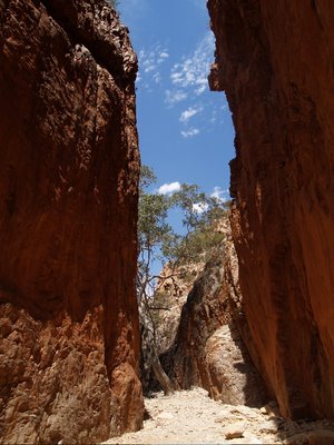
We continued down the highway to Standley Chasm, shown in the picture above, where the sun shone directly overhead and turned the canyon walls a brilliant red. Next, it was on to Ormiston Gorge. This was a huge chasm cut through rock over millions of years by wind and water. We hiked along a sandy river bed. The rivers in this part of Australia never have water for long periods of time. They fill during the rains and dry up quickly once the sun returns. In the center of these dried up waterways are large stands of gum trees. Their extensive root systems reach down deep to underground pools of water. By the time we reached the end of our hike, the sun was setting and the colours on the surrounding rock were incredible. A large swimming hole lay beneath the towering walls of the canyon, and we all took the opportunity to take a quick dip.
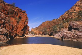
We hadn't brought any togs, so we swam o'natural. We had not seen anyone else around so it seemed the right thing to do. Unfortunately for us, a family of energetic Germans had decided to do the hike in the reverse. Hannah and I were lucky enough to have escaped the water before their arrival, but Jodi was not so fortunate! After a period of time, I came to her rescue with some clothes and she was able to leave the water. Hannah had moved to the far side of the swimming hole in an effort to disassociate herself from us!
Alice Springs to Kings Canyon

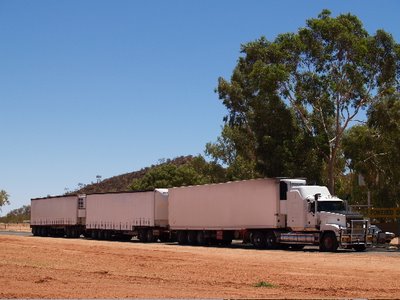
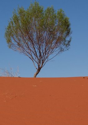
Kings Canyon is approximately 500 km from Alice Springs. The highway is narrow and has no shoulders, which makes things interesting when 55 metre road trains (think semi with three full- sized trailers) come rushing toward you. Protocol dictates you move off the road, as they do not slow down at all. As we drove along, we were struck by the utter beauty of the land. The dark blue sky, orange soil and scattered green vegetation provided extraordinary contrasts of colour.

As we neared Kings Canyon, the sky darkened and we were soon engulfed in a tremendous thunderstorm. Sheet lightning lit up the sky and thunder literally shook the motorhome. The wind was absolutely amazing. It came in gusts that would literally push the vehicle to the edge of the road. The next time Australia enters a boat in the Americas Cup Yacht race, I reckon they should try to use the body of our motorhome as a sail. I'm confident it would be a winning design! By the time we reached the entrance to the canyon, I was exhausted and Jodi was lamenting the lost photo opportunities because of the weather. We parked and decided we would try to see something of the canyon, but just as we set off, the sky opened up and we were immediately soaked to our skin. We headed down the highway to our campsite and had an early night. The next morning we woke up to a beautiful blue sky and quickly headed back to the canyon.
We began the three hour, six kilometre walk of the canyon rim. The first section required a climb up the side of the canyon to a lookout. The views were stunning. From there, we began the walk around the actual canyon. The walls of the canyon are comprised of rock structures that are unlike any we had seen before. Some resemble enormous beehives while others look like ginat layered cakes. The bright rays of the sun lit up the rock and released some amazingly vibrant shades of red and orange. The hike around the canyon has not been ruined with safety fences or warning signs. It is as nature created it millions of years ago. People are expected to exercise common sense when around the cliffs and rock falls. Jodi felt I lacked common sense in the next two photos, but she snapped the pictures anyway!


Kings Canyon to Uluru (Ayers Rock)
The next morning, we packed up and headed back down the highway to our ultimate destination, Uluru. The weather was beautiful and our drive was uneventful. We passed cattle stations, consisting of over a million acres, in the middle of nowhere. Cattle here are moved from one pasture to another in huge semi-trailers and rounded up with helicopters. About two hours down the highway, we sighted what we thought was Uluru, but it was actually another monolithe by the name of Mount Connor. It was a fascinating sight to see this wall of rock rise hundreds of meters out of the desert into the blue sky. We travelled on for another hour before we caught our first glimpse of 'The Rock'. It was now early afternoon and we headed right to the information center of Uluru. The weather began to change and large thunder clouds obscured our views of the mountain. We took a short 2 kilometer walk to the base of the rock as rain began to fall. The climb up Uluru had been closed all day because of the weather forecast. We later learned that the climb is typically closed over two hundred days of the year, sometimes due to adverse weather, high winds at the summit, or for Aboriginal ceremonies. Back at the information center, we learned heaps about the Aborginal people who have been in the area for thousands of years and who now are responsible for the stewardship of the rock and park. There is tremendous pressure on visitors not to climb Uluru for spiritual reasons. There are signs everywhere requesting that people not climb.
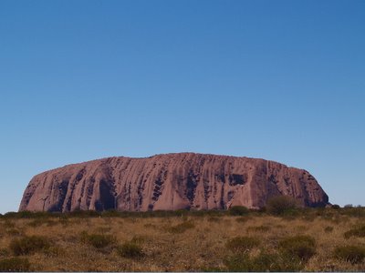
Jodi was feeling pretty disappointed in her photography prospects and I was having mixed feelings about climbing. I decided to let the spirits determine whether I would climb or not. If the weather was good in the morning, I would make the ascent. Later in the day, the sun came out and we returned to one of the viewing areas to watch the sun set on Uluru. We backed our motorhome into a parking spot, whipped up a delicious pasta meal, and sat down to watch the show. The transformation that the rock went through as the sun moved through the sky was nothing short of breathtaking. Once darkness arrived, we headed back to our campsite, excited about the prospect of seeing the sunrise the following morning.
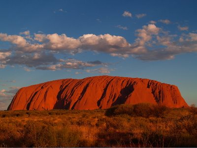
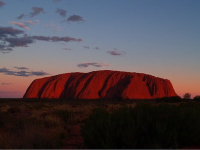

The next morning we awoke at 6:00 which is pretty darn good for a holiday morning, I think. Jodi wasn't of the same opinion because that is approximately thirty minutes past sunrise. I had set the alarm clock incorrectly. We rushed back to the other side of Uluru and caught the last bit of the sunrise.
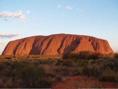
The climb was open so I decided to do it while Hannah slept and Jodi took pictures and cooked breakfast. The climb itself is much steeper than it appears. The best way to describe it is to imagine climbing up a brontosaurus's tail onto its back. The further you climb, the steeper the climb becomes. The rock is extremely smooth and there are few places to stop. A chain stretches up the first two-thirds of the climb, but it is so low that I found it more dangerous to reach down for it. I made it to the top in about forty-five minutes.

Once at the top, I was treated to a 360 degree view of the desert below. It was a wonderful experience, and I am glad I had the opportunity. Thirty-eight people have died and countless others have been injured climbing Uluru. These injuries and fatalities deeply distress the Aboriginal community, and I suspect that it won't be too long before the climb is permanently closed.
Jodi and Hannah met me at the bottom of the climb and we all enjoyed a delicious breakfast in the motorhome before heading out to the Olgas, or Kata Tjuda, which is the aboriginal name for another impressive rock formation sixty kilometers away.


The Olgas are a series of large mountains formed out of conglomerate, which is large and small rock all glued together with a mixture of sand and mud. The rock looks like chocolate chip cookie dough with massive chunks of chocolate. It was stinking hot when we arrived and the two kilometer hike was quite strenuous. At the end of the trail, we were greeted by a beautiful green oasis sandwiched between the sheer rock walls of the mountains.
Uluru to Alice Springs
We retraced our steps back to Alice Springs. The five hundred kilometer drive took us a little over six hours to complete with a few picture stops along the way. We spent the remainder of the afternoon cleaning the motorhome and packing up. There was a very nice restuarant across the street from our campground where we decided to splurge a little. Jodi was quite adventurous and ordered the kangaroo. It reminded her a little of liver. Hannah and I were quite happy with our Australian chicken. We had an amazing trip and were all glad we had a chance to see the red center of Oz.
Our flight from Brisbane to Alice Springs took a little over three hours. It was fascinating to stare down at the landscape from thirty thousand feet. Dried up river systems and and a semi-arid desert of red sand stretched out as far as the eye could see. Once on the ground, we headed off to collect our motorhome, which would be home for the next week.
After a quick explanation of the workings of the motorhome and the obligatory pressure to purchase additional insurance, we were off! We shopped for groceries and then headed up the highway to explore the sights. One of our first stops was a gap in the East McDonald Mountain Range. We hiked up a dried-up river to some cliffs where several aboriginal pictographs could be viewed. These paintings depict Dreamtime stories, which typically explain how people and other natural surroundings, such as mountains, came to be. This particular one shows the Caterpillar people creating Emily and Jessie Gaps.

We continued down the highway, stopping frequently to take pictures and explore various sites of interest. There is no speed limit in the Territory so I was able to really wind up our Mercedes motorhome. I soon slowed down when I observed the fuel guage dropping by the minute. With diesel costing $1.67 a litre, I decided to curb my need for speed. Our return trip to Alice Springs began at dusk and ended in the dark. Our average speed fell to around 40 km/h. It was a miracle we didn't hit any kangaroos or cattle that range freely along the side of the road. They were everywhere and almost impossible to see until you were right on top of them. For the second time this year, we wondered whether we should have bought that 'extra' insurance. Once Jodi pried my white knuckles from the steering wheel, we enjoyed a quiet evening at our campground.
The next day we headed the opposite direction along the McDonald Range. We stopped at some more 'gaps'. At Simpson's Gap, we were able to view towering red canyon walls, rock wallabies, and water holes that were home to an amazing variety of plant and animal life. Hannah loved scrambling over the rock, and we had our hands full keeping up with her.

We continued down the highway to Standley Chasm, shown in the picture above, where the sun shone directly overhead and turned the canyon walls a brilliant red. Next, it was on to Ormiston Gorge. This was a huge chasm cut through rock over millions of years by wind and water. We hiked along a sandy river bed. The rivers in this part of Australia never have water for long periods of time. They fill during the rains and dry up quickly once the sun returns. In the center of these dried up waterways are large stands of gum trees. Their extensive root systems reach down deep to underground pools of water. By the time we reached the end of our hike, the sun was setting and the colours on the surrounding rock were incredible. A large swimming hole lay beneath the towering walls of the canyon, and we all took the opportunity to take a quick dip.

We hadn't brought any togs, so we swam o'natural. We had not seen anyone else around so it seemed the right thing to do. Unfortunately for us, a family of energetic Germans had decided to do the hike in the reverse. Hannah and I were lucky enough to have escaped the water before their arrival, but Jodi was not so fortunate! After a period of time, I came to her rescue with some clothes and she was able to leave the water. Hannah had moved to the far side of the swimming hole in an effort to disassociate herself from us!
Alice Springs to Kings Canyon

Kings Canyon is approximately 500 km from Alice Springs. The highway is narrow and has no shoulders, which makes things interesting when 55 metre road trains (think semi with three full- sized trailers) come rushing toward you. Protocol dictates you move off the road, as they do not slow down at all. As we drove along, we were struck by the utter beauty of the land. The dark blue sky, orange soil and scattered green vegetation provided extraordinary contrasts of colour.


As we neared Kings Canyon, the sky darkened and we were soon engulfed in a tremendous thunderstorm. Sheet lightning lit up the sky and thunder literally shook the motorhome. The wind was absolutely amazing. It came in gusts that would literally push the vehicle to the edge of the road. The next time Australia enters a boat in the Americas Cup Yacht race, I reckon they should try to use the body of our motorhome as a sail. I'm confident it would be a winning design! By the time we reached the entrance to the canyon, I was exhausted and Jodi was lamenting the lost photo opportunities because of the weather. We parked and decided we would try to see something of the canyon, but just as we set off, the sky opened up and we were immediately soaked to our skin. We headed down the highway to our campsite and had an early night. The next morning we woke up to a beautiful blue sky and quickly headed back to the canyon.
We began the three hour, six kilometre walk of the canyon rim. The first section required a climb up the side of the canyon to a lookout. The views were stunning. From there, we began the walk around the actual canyon. The walls of the canyon are comprised of rock structures that are unlike any we had seen before. Some resemble enormous beehives while others look like ginat layered cakes. The bright rays of the sun lit up the rock and released some amazingly vibrant shades of red and orange. The hike around the canyon has not been ruined with safety fences or warning signs. It is as nature created it millions of years ago. People are expected to exercise common sense when around the cliffs and rock falls. Jodi felt I lacked common sense in the next two photos, but she snapped the pictures anyway!


Kings Canyon to Uluru (Ayers Rock)
The next morning, we packed up and headed back down the highway to our ultimate destination, Uluru. The weather was beautiful and our drive was uneventful. We passed cattle stations, consisting of over a million acres, in the middle of nowhere. Cattle here are moved from one pasture to another in huge semi-trailers and rounded up with helicopters. About two hours down the highway, we sighted what we thought was Uluru, but it was actually another monolithe by the name of Mount Connor. It was a fascinating sight to see this wall of rock rise hundreds of meters out of the desert into the blue sky. We travelled on for another hour before we caught our first glimpse of 'The Rock'. It was now early afternoon and we headed right to the information center of Uluru. The weather began to change and large thunder clouds obscured our views of the mountain. We took a short 2 kilometer walk to the base of the rock as rain began to fall. The climb up Uluru had been closed all day because of the weather forecast. We later learned that the climb is typically closed over two hundred days of the year, sometimes due to adverse weather, high winds at the summit, or for Aboriginal ceremonies. Back at the information center, we learned heaps about the Aborginal people who have been in the area for thousands of years and who now are responsible for the stewardship of the rock and park. There is tremendous pressure on visitors not to climb Uluru for spiritual reasons. There are signs everywhere requesting that people not climb.

Jodi was feeling pretty disappointed in her photography prospects and I was having mixed feelings about climbing. I decided to let the spirits determine whether I would climb or not. If the weather was good in the morning, I would make the ascent. Later in the day, the sun came out and we returned to one of the viewing areas to watch the sun set on Uluru. We backed our motorhome into a parking spot, whipped up a delicious pasta meal, and sat down to watch the show. The transformation that the rock went through as the sun moved through the sky was nothing short of breathtaking. Once darkness arrived, we headed back to our campsite, excited about the prospect of seeing the sunrise the following morning.


The next morning we awoke at 6:00 which is pretty darn good for a holiday morning, I think. Jodi wasn't of the same opinion because that is approximately thirty minutes past sunrise. I had set the alarm clock incorrectly. We rushed back to the other side of Uluru and caught the last bit of the sunrise.

The climb was open so I decided to do it while Hannah slept and Jodi took pictures and cooked breakfast. The climb itself is much steeper than it appears. The best way to describe it is to imagine climbing up a brontosaurus's tail onto its back. The further you climb, the steeper the climb becomes. The rock is extremely smooth and there are few places to stop. A chain stretches up the first two-thirds of the climb, but it is so low that I found it more dangerous to reach down for it. I made it to the top in about forty-five minutes.

Once at the top, I was treated to a 360 degree view of the desert below. It was a wonderful experience, and I am glad I had the opportunity. Thirty-eight people have died and countless others have been injured climbing Uluru. These injuries and fatalities deeply distress the Aboriginal community, and I suspect that it won't be too long before the climb is permanently closed.
Jodi and Hannah met me at the bottom of the climb and we all enjoyed a delicious breakfast in the motorhome before heading out to the Olgas, or Kata Tjuda, which is the aboriginal name for another impressive rock formation sixty kilometers away.


The Olgas are a series of large mountains formed out of conglomerate, which is large and small rock all glued together with a mixture of sand and mud. The rock looks like chocolate chip cookie dough with massive chunks of chocolate. It was stinking hot when we arrived and the two kilometer hike was quite strenuous. At the end of the trail, we were greeted by a beautiful green oasis sandwiched between the sheer rock walls of the mountains.
Uluru to Alice Springs
We retraced our steps back to Alice Springs. The five hundred kilometer drive took us a little over six hours to complete with a few picture stops along the way. We spent the remainder of the afternoon cleaning the motorhome and packing up. There was a very nice restuarant across the street from our campground where we decided to splurge a little. Jodi was quite adventurous and ordered the kangaroo. It reminded her a little of liver. Hannah and I were quite happy with our Australian chicken. We had an amazing trip and were all glad we had a chance to see the red center of Oz.


3 Comments:
Great entry! We had been wondering how you'd been doing and what you'd been doing recently. Love the pics of Ayers Rock! Can't believe you climbed it though... talk about damnation!
Looking forward to your return. Unfortunately, due to a clerical error, your Grade 2 classroom is in Old Yennadon.
Enjoy your last few weeks!
Great experience and photos. Every Aussie should go there!
I'd like to read the Germans' travel blog.
Well I think Jodi may have been right about you lacking common sense. I was scared with you on that cliff and I am sitting at the computer so If I was there I'm sure I would of agreed with Jodi.
What amazing photos thanks for the Aussi update
Love Stacey
The kids say thanks for the postcards
Post a Comment
<< Home